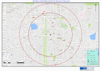
We just upgraded our GIS Basic Training Package
We just upgraded our GIS Basic Training Package, for those who wanted to start exploring the amazing industry. Please click below to check for the new course content. http://sysglob.in/gis-courses-beginner.html TOPICS WE COVER: Desktop: Google Earth Pro, ArcGIS (ArcCatalog, ArcView, ArcMap) Or QGIS Desktop, GIS Online Portal for Raster and Vector Collection(USGS Explorer & Bhuvan Web Portal,) Duration: 24 Hr